DVRPC views the bicycle as a mode of transportation rather than just a form of recreation. Many short trips that are presently made by car, could be made by bicycle if safer and more comfortable bicycle accommodations were provided. Traveling by bicycle leads to positive results for health, air quality, automobile congestion, and overall regional mobility. DVRPC encourages context-sensitive bicycle accommodations throughout the region as a part of a complete streets framework. Complete streets are those that accommodate pedestrians, bicyclists, transit, and cars, and allow us to maximize regional transportation choices and mobility. We support local bicycle planning efforts through data collection, specific planning projects, and the identification of emerging national and international best practices that may be appropriate for our region.
Planning Tools
To support effective bicycle planning, DVRPC develops planning tools to understand more about what is happening in the region and how to plan for the future.
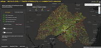
Level of Traffic Stress (LTS) is a road classification scheme based on the comfort of bicyclists using that road. DVRPC’s LTS assignment is based on the number of lanes, effective vehicle speed, and presence/type of bicycle facility. The Connectivity Analysis was conducted to determine which segments provide the greatest number of connections throughout the region, from every census block to every other census block.
To support effective bicycle planning, DVRPC has an ongoing program to collect bicycle counts on roadways and trails throughout the region using pneumatic tube equipment. In 2014, DVRPC started a Cyclical Bike Count Program, which strategically counts bikes in representative locations around the region on a regular basis. The program will help track bicycling trends over time. Counts associated with that program, as well as all other counts conducted since 2010, can be found in the Pedestrian and Bicycle Count Viewer.
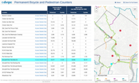
Thanks to generous support from the William Penn Foundation and the Pennsylvania Environmental Council, who provided funds for equipment acquisition, DVRPC began a permanent counting program at over 10 locations along Circuit Trails around the region. Bicyclists and pedestrians will be counted 24-hours per day, 365-days per year at these locations, and the data are accessible to everyone online!
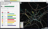
RideScore is an online database that assesses the physical and demographic characteristics around transit stations that relate to how supportive of bicycling the area is, or could be. The database focuses on commuter rail stations outside of Center City Philadelphia as well as trolley and subway terminals, where having direct, safe, and nonmotorized access between transit stations and a person's origin and/or destination is a challenge.
Recent Publications
DVRPC routinely conducts a number of bicycle access and planning specific studies. Listed here are the most recent publications. These products are available through our Resource Center at 215-592-1800 or via email at public_affairs@dvrpc.org.
This study used best practices from the National Association of City Transportation Officials, Portland State University, and Portland Bureau of Transportation to develop a two-part geographic information system methodology that identified suitable streets to build neighborhood greenways in each of Philadelphia’s 10 city council districts. Neighborhood greenways are low-volume, low-stress streets that prioritize bicycle and pedestrian travel over vehicles.
This report summarizes the traits common to curbless streets in peer cities within the United States, the benefits of their use and special considerations, and offers suggestions on selecting potential sites and design tools for use within candidate streets.
This plan includes a comprehensive analysis of existing conditions along Washington Avenue between Front Street and Columbus Boulevard in Philadelphia and offers two conceptual designs that identify opportunities to improve bicycle and pedestrian movement in the area, along with estimated construction costs.
The plan includes a comprehensive analysis of existing conditions between the Benjamin Franklin Bridge and the Delaware River in Philadelphia and offers conceptual designs that identify opportunities to improve bicycle connections and safety in the area.
This study proposes different bicycle, pedestrian, intersection, and trail interventions within downtown Trenton, New Jersey. The plan also offers potential funding streams and examples of estimated construction costs. This plan will be incorporated into the City of Trenton’s Trenton250 Master Plan.
This report provides general guidance and conceptual recommendations for a multi-use sidepath running parallel to South Broad Street from Oregon Avenue to the Philadelphia Navy Yard. This facility was proposed in the city’s pedestrian and bicycle master plan.
The DVRPC/PennDOT Connects Bike-Friendly Resurfacing Program is an effort to identify roads for potential investment in bike friendly improvements as part of regularly scheduled PennDOT resurfacing projects.
To support effective pedestrian planning, DVRPC has an ongoing program to collect pedestrian counts on roadways and trails throughout the region using infrared equipment.
The Regional Trails Program, administered by DVRPC with funding from the William Penn Foundation, aims to capitalize upon opportunities for trail development by providing funding for targeted, priority trail design, construction and planning projects that will promote a truly connected, regional network of multi-use trails with Philadelphia and Camden as its hub. The program also provides technical assistance to trail developers, counties, municipalities and nonprofit organizations. Greater Philadelphia's regional trails network has been named The Circuit. Today, The Circuit is comprised of 250+ miles of walking and biking trails in the Greater Philadelphia region. When complete, The Circuit will be 800 miles of bicycle and pedestrian trails connecting the region’s communities, jobs, and parks.
This technical assistance program matches eligible municipalities and counties with DVRPC staff to navigate the often-complex process of designing and funding pedestrian and bicycle improvements around rail stations.
Greater Philadelphia benefits from a strong multimodal transportation system. This page highlights municipal tools to encourage environmentally friendly alternative forms of transportation, such as walking, biking, and transit.
Bikeability is an estimate of how comfortable it is to bike along a roadway, and considers many factors, including traffic volumes, traffic speeds, pavement widths, and whether there is a usable shoulder. In cooperation with Mercer County, DVRPC staff calculated Bikeability Scores for Mercer County roadways using the Bicycle Level of Service (BLOS) model, which generates a BLOS grade for any roadway based on the above factors (and others).
This report provides information about recommended practices and ordinances that enhance pedestrian and bicycle safety and accommodations. Encouragement and safety campaigns are also highlighted.
The TA Set-Aside Program provides funds to build pedestrian and bicycle facilities, improve access to public transportation, create safe routes to school, preserve historic transportation structures, provide environmental mitigation, and create trail projects that serve a transportation purpose while promoting safety and mobility. Local governments, regional transportation authorities, transit agencies, natural resource or public land agencies, school districts, local education agencies, or schools, and tribal governments are eligible to apply for the periodically available competitive TA Set-Aside funds.